Why Choose Our Land Survey Equipment?

Land survey equipment is essential for professionals in construction, engineering, and real estate, providing the tools necessary to measure and map the physical features of the Earth.
These instruments are crucial for ensuring accuracy in projects ranging from large-scale construction to detailed topographical surveys.
Mountlaser suppliers, we offer a wide selection of land survey equipment designed to meet the diverse needs of our clients. In this article, we will explore the advantages and unique features of our land survey equipment, as well as key considerations when selecting the right tools for your projects.
Land survey equipment encompasses a variety of tools designed for measuring and mapping the physical features of the Earth.

1. Total Stations
Description: Combines electronic theodolite and distance measuring capabilities.
Use: Used for precise angle and distance measurements in surveying.
2. GPS Survey Equipment
Description: Includes handheld GPS units and more advanced GNSS systems.
Use: Provides accurate positioning and navigation data for large areas.
3. Leveling Instruments
Description: Includes optical levels and digital levels.
Use: Used to determine height differences and establish horizontal planes.
4. Theodolites
Description: Instruments for measuring horizontal and vertical angles.
Use: Essential for triangulation and layout work.
5. Measuring Tapes and Chains
Description: Simple tools for linear measurements.
Use: Used for measuring distances in various surveying applications.
6. Plumb Bobs
Description: Simple tools that indicate vertical alignment.
Use: Used for establishing vertical references.
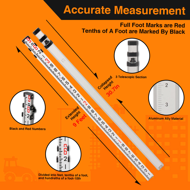
7. Surveying Rods
Description: Graduated rods used in conjunction with leveling instruments.
Use: Used to measure height differences during leveling.
8. Data Collectors
Description: Handheld devices used to collect and process survey data.
Use: Interface with other surveying equipment and store data for analysis.
9. Laser Scanners
Description: Equipment that uses laser beams to capture 3D data.
Use: Used for detailed topographical mapping and modeling.
10. Prism Assemblies
Description: Reflective devices used in conjunction with total stations.
Use: Help in measuring distances accurately.

These tools collectively enable surveyors to conduct precise measurements, create maps, and ensure the accuracy of construction and engineering projects.
Advantages of Mountlaser Land Survey Equipment
1. Precision and Accuracy
One of the primary advantages of our land survey equipment is its precision. Our instruments are designed to provide highly accurate measurements, ensuring that your surveys are reliable and trustworthy. Whether you are using total stations, GPS systems, or leveling instruments, you can count on our equipment to deliver results that meet the highest standards of accuracy.
2. Durability and Reliability
Our land survey equipment is built to withstand tough working conditions. Constructed from high-quality materials, these tools are resistant to wear and tear, ensuring longevity even in harsh environments. This durability means you can rely on our equipment for consistent performance, reducing the need for frequent replacements and repairs.
3. User-Friendly Design
We understand that ease of use is crucial for professionals in the field. Our land survey equipment features intuitive interfaces and ergonomic designs that simplify operation. This focus on user experience allows surveyors to work efficiently, minimizing the learning curve and enhancing productivity on site.
4. Advanced Technology
At Mountlaser, we incorporate the latest technology into our land survey equipment. Our products are equipped with innovative features such as digital displays, Bluetooth connectivity, and automated data collection systems. These advancements streamline the surveying process, allowing for quicker and more accurate data acquisition.
When purchasing land survey equipment, several factors should be taken into account to ensure you make the best choice for your needs:
1. Project Requirements
Consider the specific requirements of your project. Different types of surveys may necessitate different equipment, so it's essential to assess what tools will best suit your objectives.
2. Budget
Establish a budget that balances quality and cost. While it may be tempting to choose the cheapest option, investing in high-quality land survey equipment can save you money in the long run by reducing maintenance costs and improving accuracy.
3. Manufacturer Reputation
Research the reputation of the manufacturer. Choose a brand known for its reliability and customer service. At Mountlaser, we pride ourselves on our commitment to quality and support, ensuring you have assistance whenever you need it.
Land Survey Equipment Addressing Market Pain Points
In the current market, many survey professionals face challenges such as outdated equipment, lack of support, and difficulties with data management. Our land survey equipment directly addresses these issues by providing advanced technology, robust customer support, and user-friendly designs that simplify data handling. By investing in our tools, you can overcome common obstacles and enhance your surveying capabilities.

Conclusion
In summary, our land survey equipment offers exceptional precision, durability, and advanced technology, making it the ideal choice for professionals in the surveying industry. With unique features such as integrated data management systems and environmentally friendly options, our products stand out in the market. If you are in the market for high-quality land survey equipment, contact Mountlaser today to discover our range of innovative solutions. Your next project deserves the best tools available!


