
Best Selling Survey Tools of 2025: Professional Equipment Guide
Understanding Modern Survey Tool Requirements
The surveying landscape has undergone profound metamorphosis in recent years, with technological convergence reshaping professional expectations. Contemporary survey professionals demand instruments that seamlessly integrate with digital workflows while maintaining the ruggedness essential for fieldwork. The proliferation of Building Information Modeling (BIM) and Geographic Information Systems (GIS) has elevated precision standards beyond traditional tolerances.
Modern surveying environments present multifaceted challenges that extend far beyond basic measurement acquisition. Professionals encounter diverse terrain conditions, atmospheric variables, and project-specific accuracy requirements that necessitate versatile instrumentation portfolios. The shift toward real-time data processing has fundamentally altered how survey teams approach project execution, emphasizing connectivity and instantaneous verification protocols.
Equipment durability remains paramount, yet contemporary tools must balance robustness with sophisticated electronic components. The integration of GNSS receivers, laser technologies, and digital imaging systems within single platforms demands careful consideration of environmental protection ratings and operational temperature ranges. Professional surveyors increasingly seek instruments that deliver consistent performance across diverse climatic conditions while maintaining calibration stability over extended deployment periods.
Professional-Grade Surveying Equipment Categories
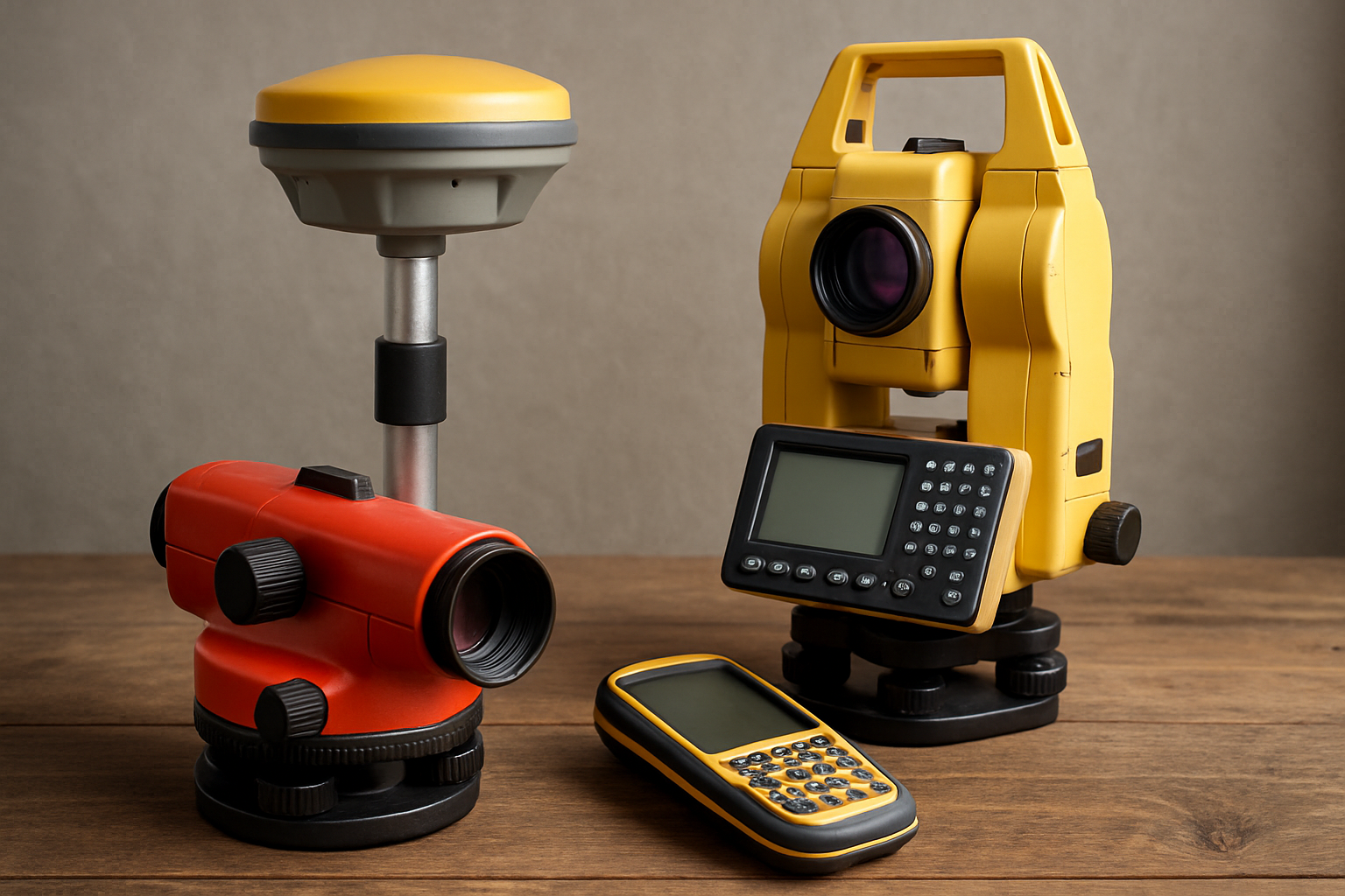
Total Stations and Theodolites
Total stations represent the cornerstone of contemporary surveying operations, combining angular measurement precision with electronic distance measurement capabilities. These sophisticated instruments have evolved to incorporate robotic functionality, enabling single-operator workflows that significantly enhance productivity. Modern total stations feature enhanced prism tracking algorithms and advanced atmospheric correction systems that maintain accuracy across challenging environmental conditions.

The latest generation incorporates touchscreen interfaces and intuitive software platforms that streamline data collection protocols. Reflectorless measurement capabilities extend operational versatility, allowing measurements to surfaces and structures previously inaccessible through conventional prism-based methodologies. Professional-grade models maintain angular accuracies within one-second tolerances while delivering distance measurements with millimeter precision.
GNSS and GPS Systems
Global Navigation Satellite System technology continues advancing through multi-constellation support and enhanced signal processing algorithms. Contemporary GNSS receivers leverage signals from GPS, GLONASS, Galileo, and BeiDou constellations simultaneously, providing unprecedented positioning reliability and accuracy. Real-Time Kinematic (RTK) correction services enable centimeter-level positioning for demanding surveying applications.
Professional GNSS systems incorporate sophisticated antenna designs that minimize multipath errors while maintaining signal acquisition in challenging environments. The integration of inertial measurement units (IMUs) provides continuous positioning during temporary signal occlusion, ensuring uninterrupted workflow progression. Advanced GNSS controllers feature rugged construction with extended battery life optimized for full-day field operations.
Laser Measurement Technologies
Laser-based measurement systems encompass diverse technologies ranging from handheld distance meters to sophisticated scanning platforms. Rotary laser levels provide essential horizontal and vertical reference planes for construction layout applications, while laser rangefinders deliver precise distance measurements across extended ranges. The emergence of compact laser scanning systems has democratized three-dimensional data capture for routine surveying projects.
Professional laser systems incorporate multiple wavelength options optimized for specific surface materials and environmental conditions. Advanced atmospheric compensation algorithms maintain measurement accuracy across varying temperature and humidity conditions. Battery management systems ensure consistent laser output throughout extended measurement sessions while providing low-power operation modes for extended deployment scenarios.
Mountlaser's Best-Selling Collection for Survey Professionals
Recognizing the diverse requirements of modern survey professionals, Mountlaser has curated a comprehensive collection of precision instruments designed to address the most demanding field applications. This carefully selected assortment encompasses essential surveying tools that have proven their reliability across countless professional projects worldwide.
The collection represents a convergence of proven technologies and innovative design approaches, specifically tailored for professionals who refuse to compromise on accuracy or durability. Each instrument within this selection has undergone rigorous field testing to ensure consistent performance under adverse conditions. From precision prisms and robust tripods to advanced distance measurement systems, these tools form the foundation of professional surveying operations.
These meticulously engineered instruments address the critical need for reliable, accurate surveying equipment that maintains performance standards across diverse environmental conditions. The collection emphasizes practical design elements that enhance workflow efficiency while providing the precision required for professional applications.
Essential Accessories and Support Equipment
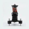
Prisms and Reflective Systems
Survey prisms serve as fundamental components in electronic distance measurement systems, requiring exceptional optical quality and mechanical stability. Contemporary prism assemblies incorporate advanced optical coatings that maximize signal return while minimizing atmospheric interference effects. Professional-grade prisms maintain constant offset specifications across temperature variations, ensuring measurement consistency throughout extended deployment periods.
Prism mounting systems have evolved to provide enhanced versatility and rapid deployment capabilities. Tilting mechanisms enable precise horizontal positioning while maintaining vertical alignment, crucial for accurate angular measurements. Robust construction materials resist impact damage while providing corrosion resistance essential for diverse environmental exposures.

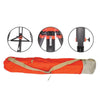
Tripods and Mounting Systems
Professional surveying tripods balance stability requirements with portability considerations essential for efficient field operations. Contemporary designs incorporate lightweight materials without compromising structural rigidity necessary for precise instrument positioning. Advanced leg locking mechanisms provide secure positioning across uneven terrain while enabling rapid setup and breakdown procedures.
Specialized mounting systems accommodate diverse instrument configurations while maintaining compatibility across multiple equipment platforms. Quick-release mechanisms facilitate efficient instrument exchanges while ensuring consistent positioning accuracy. Professional tripods feature adjustable leg lengths and angular positioning capabilities that accommodate challenging terrain conditions.
3D Scanning and Advanced Measurement Technologies
Three-dimensional laser scanning has revolutionized data acquisition methodologies, enabling comprehensive spatial documentation with unprecedented detail levels. Contemporary scanning systems combine high-resolution imagery with precise distance measurements, creating detailed point clouds suitable for advanced modeling applications. Professional scanners maintain measurement accuracies within millimeter tolerances while capturing millions of data points per second.
Terrestrial laser scanners have become increasingly portable while maintaining professional-grade accuracy specifications. Advanced registration algorithms enable seamless integration of multiple scan positions, creating comprehensive three-dimensional models of complex structures and terrain features. Real-time visualization capabilities allow field verification of data quality, minimizing the need for return site visits.
"The integration of 3D scanning technology with traditional surveying methodologies has fundamentally transformed how we approach complex measurement challenges, providing unprecedented insight into spatial relationships and geometric complexities."
Scanner Targets and Registration Systems
Precise scan registration requires specialized targets that provide unambiguous reference points across multiple instrument positions. Contemporary scanner targets incorporate retroreflective materials optimized for specific laser wavelengths while maintaining dimensional stability across temperature variations. Professional target systems enable automated recognition algorithms that streamline registration workflows.
Advanced registration methodologies leverage both artificial targets and natural feature recognition to optimize accuracy and efficiency. Spherical targets provide omnidirectional reflectance characteristics essential for multi-station scanning projects, while planar targets offer enhanced accuracy for specific geometric configurations. Target mounting systems provide stable positioning while enabling rapid deployment across diverse surfaces.
Selection Criteria for Professional Survey Equipment
Selecting appropriate surveying instruments requires careful evaluation of project-specific requirements, environmental conditions, and accuracy specifications. Professional surveyors must consider long-term reliability factors alongside immediate performance capabilities when investing in measurement systems. Equipment compatibility across diverse platforms ensures maximum utility while minimizing redundant acquisitions.
| Equipment Category | Primary Applications | Key Specifications | Environmental Considerations |
| Total Stations | Boundary surveys, construction layout, topographic mapping | Angular accuracy ±1", Distance accuracy ±2mm | Operating temperature -20°C to +50°C, IP65 rating |
| GNSS Systems | Geodetic control, GIS data collection, machine control | RTK accuracy ±10mm horizontal, ±20mm vertical | Multi-constellation support, anti-jamming capabilities |
| Laser Scanners | As-built documentation, deformation monitoring, archaeology | Range accuracy ±2mm, angular accuracy 0.009° | Dust and moisture resistance, temperature compensation |
Accuracy and Precision Requirements
Professional surveying applications demand instruments that consistently deliver measurements within specified tolerance ranges. Understanding the distinction between accuracy and precision enables informed equipment selection based on project-specific requirements. Accuracy refers to measurement proximity to true values, while precision indicates measurement repeatability under consistent conditions.
Contemporary instruments provide accuracy specifications under standardized conditions, yet field performance may vary based on environmental factors and operational methodologies. Professional surveyors must evaluate manufacturer specifications against real-world application requirements, considering factors such as atmospheric conditions, target surface characteristics, and measurement range limitations.
Maintenance and Calibration Considerations
Professional survey instruments require systematic maintenance protocols to ensure continued accuracy and reliability throughout their operational lifespan. Regular calibration verification using certified reference standards identifies potential drift conditions before they compromise measurement quality. Preventive maintenance schedules should address both mechanical components and electronic systems to maximize instrument longevity.
Environmental exposure presents ongoing challenges to instrument calibration stability, particularly for electronic distance measurement systems and angular encoders. Professional-grade instruments typically provide field adjustment capabilities that enable technicians to correct minor calibration errors without returning equipment to manufacturer service facilities. However, significant calibration discrepancies require professional service intervention to restore factory specifications.
Proper storage and transportation protocols significantly influence instrument reliability and calibration stability. Protective cases should provide adequate shock absorption while maintaining temperature and humidity control during transport and storage. Battery management systems require periodic cycling to maintain optimal performance characteristics, while optical components demand careful cleaning procedures to prevent surface damage.

The surveying profession continues evolving through technological advancement and changing industry requirements. Professional surveyors who invest in quality instrumentation from established manufacturers position themselves for sustained success across diverse project applications. Understanding equipment capabilities and limitations enables informed decision-making that balances performance requirements with budgetary considerations.
Evaluate long-term support availability from manufacturers
Consider equipment compatibility with existing software platforms
Assess training requirements for new technology adoption
Review warranty terms and service network accessibility
Analyze total cost of ownership including consumables and maintenance
Contemporary survey professionals benefit from unprecedented access to sophisticated measurement technologies that enhance productivity while maintaining traditional accuracy standards. The key to successful equipment selection lies in matching instrument capabilities to specific application requirements while considering long-term reliability and support factors. As surveying continues integrating with emerging technologies, professionals who embrace proven solutions while remaining adaptable to innovation will continue thriving in this dynamic field.
-
Posted in
laser levels, surveying equipment, total stations