What is the most common of land survey equipment?
Understanding Land Survey Equipment
Land survey equipment is essential for accurately measuring and mapping the Earth's surface. It encompasses a wide range of tools and devices used by surveyors to collect data, establish boundaries, and perform various types of spatial measurements. From construction projects to property disputes, the accuracy and reliability of land survey equipment play a crucial role in achieving precise results. Among the diverse array of land survey equipment available, the total station stands out as the most common and versatile instrument used in the field.
Common Land Survey Equipment
1. Total Station
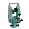
The total station is arguably the most ubiquitous piece of land survey equipment. It integrates the functions of an electronic theodolite and an electronic distance meter (EDM) into a single device. This combination allows for precise measurement of angles and distances. Modern total stations are equipped with data storage and processing capabilities, making them highly efficient for various surveying tasks. They are used for boundary surveys, topographic surveys, and construction staking. The total station’s versatility, accuracy, and ability to store data electronically make it indispensable for surveyors.
2. GPS Survey Equipment
Global Positioning System (GPS) survey equipment is another common tool in land surveying. GPS equipment determines the precise location of a point on the Earth's surface by receiving signals from satellites. It provides high accuracy for large-scale surveys and is essential for geodetic and cadastral work. Modern GPS systems often include real-time kinematic (RTK) technology, which enhances accuracy and is particularly useful for high-precision applications like construction and mapping.

3. Laser Scanners
Laser scanners are used to capture detailed three-dimensional data of objects and environments. They work by emitting laser beams and recording the time it takes for the beams to return, creating a point cloud that represents the scanned area. This equipment is valuable for creating detailed 3D models of terrain, buildings, and structures. Laser scanning is especially useful in archaeological surveys, architectural documentation, and large-scale infrastructure projects.

4. Leveling Instruments
Leveling instruments, such as optical levels and digital levels, are used to measure vertical distances and determine elevation differences between points. These tools are critical for creating accurate topographic maps and ensuring the proper leveling of construction projects. Optical levels rely on traditional optical methods, while digital levels offer enhanced precision and automation.
5. Theodolites
Theodolites are traditional land survey instruments used to measure horizontal and vertical angles. Though less common in modern surveying due to the advent of total stations, they are still used for specific applications and in educational settings. Theodolites are known for their precision and reliability in angle measurement.
Land Survey EquipmentUnique Features and Innovations
The total station’s dominance in the field of land survey equipment can be attributed to several unique features and innovations:
Integrated Technology: Total stations combine angle and distance measurement in one device, streamlining the surveying process and reducing the need for multiple instruments.
Data Processing and Storage: Modern total stations come equipped with advanced software for data processing, allowing surveyors to perform calculations and analysis on-site.
GPS Integration: Some total stations feature GPS integration, enhancing accuracy and providing geospatial data for comprehensive surveys.
Laser scanners have also introduced significant innovations:
High-Resolution 3D Mapping: Laser scanners offer detailed 3D mapping capabilities, capturing intricate details and providing valuable data for complex projects.
Efficiency: They can quickly scan large areas, saving time compared to traditional surveying methods.

When selecting land survey equipment, consider the following factors:
Accuracy: Ensure the equipment meets the precision requirements for your specific surveying tasks.
Functionality: Choose equipment that aligns with your surveying needs, whether it's for boundary determination, topographic mapping, or 3D modeling.
Ease of Use: Consider the learning curve and user-friendliness of the equipment, especially if it will be operated by multiple users.
Support and Service: Opt for equipment from reputable manufacturers that offer reliable support and service.
If you are searching for "land survey equipment near me," it is essential to choose a supplier known for quality products and customer support. Mountlaser is a renowned manufacturer of land survey equipment, offering a wide range of products and excellent service. They provide state-of-the-art equipment and are well-regarded for their expertise in the field.
Conclusion
In summary, the total station is the most common and versatile land survey equipment, known for its integration of angle and distance measurement, data processing capabilities, and GPS integration.
Other notable equipment includes GPS systems, laser scanners, leveling instruments, and theodolites, each serving specific functions in the surveying process. When selecting land survey equipment, prioritize accuracy, functionality, ease of use, and reliable support. For high-quality land survey equipment, consider contacting Mountlaser, a leading manufacturer known for its innovative solutions and excellent customer service.

